Habitat Classification and Ocean Mapping (HCOM) Subcommittee
Featured Activities
For more information on any of the projects below, please contact the HCOM leadership team:
Seascapes
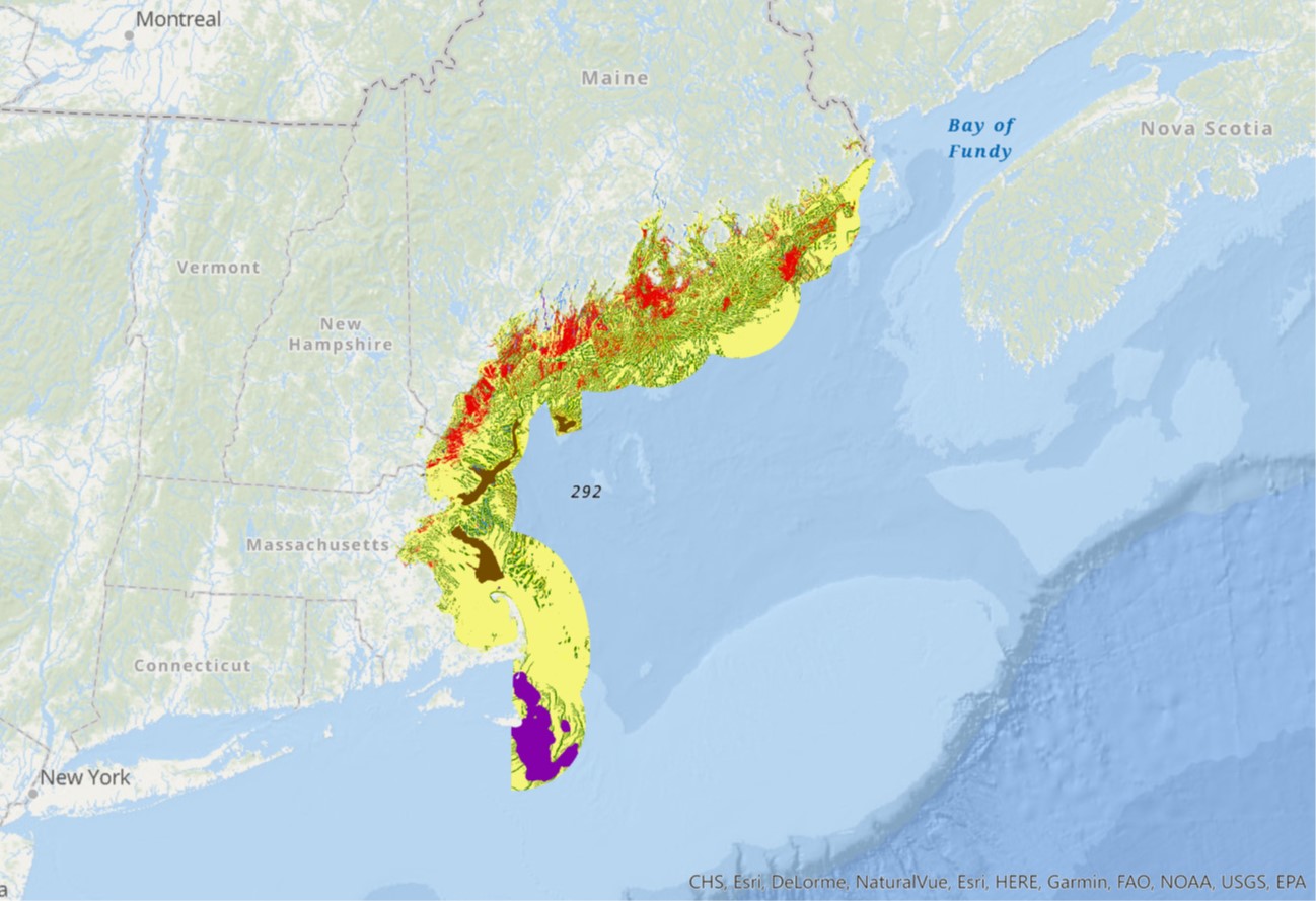 The goals of the Seascapes project are 1) to provide a better understanding of the intersection of important habitat areas and proposed projects that are within the NROC planning area (Connecticut to Maine) and 2) to produce a landscape-scale depiction of seafloor structures (geoforms) using a uniform base layer and classification criteria that will inform future planning and be updateable by partners in the region. The Seascapes project uses a standardized technique that incorporates data formatted into an agreed-upon habitat classification system—the Coastal Marine Ecological Classification Standard (CMECS)—that provides clarity for all stakeholders.
Why is this work needed? The region is experiencing an increase in proposed multijurisdictional energy projects that may impact the seabed. The intent is that state coastal programs and their federal partners will use Seascapes in their planning for multiple ocean uses and in their review and formal comments on proposed projects. The Seascape project may also inform habitat identification and fisheries habitat modeling.
Seafloor Mapping Prioritization
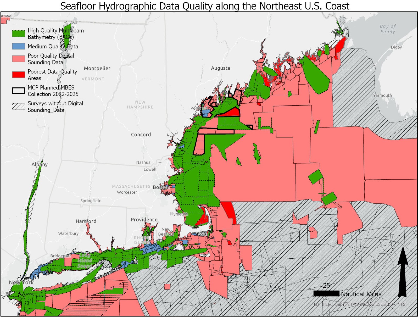 HCOM is working with NOAA’s Office for Coast Management and National Centers for Coastal Ocean Science to identify priority areas for new data collection and mapping in the northeast. The process will involve a broad group of stakeholders and employ participatory GIS survey and analysis methods.
CMECS Updates
 HCOM team members are working with mapping specialists from across the United States to update and refine NOAA’s Coastal and Marine Ecological Classification Standard (CMECS) habitat classification framework. Recent changes to CMECS include refinement of definitions to clarify meanings and reduce redundancy, as well as improvements to the classification hierarchy allowing the standard to be applied more easily with different technologies. Results from the Seascapes project are directly contributing to this process.
Annual Work Plan
The HCOM leadership team updates its work plan annually to focus resources on regional interests in marine habitat classification and seafloor mapping and to support broader NROC goals
- Link to 2021-2023 Work Plan
- Link to the November 14, 2022 work plan presentation to NROC
HCOM Membership
- Bureau of Ocean Energy Management
- Center for Coastal Studies
- Connecticut Department of Energy and Environmental Protection
- Maine Coastal Program
- Maine Geological Survey
- Maine The Nature Conservancy
- Massachusetts Bay National Estuary Partnership
- Massachusetts Division of Marine Fisheries
- Massachusetts Office of Coastal Zone Management
- National Park Service
- New England Fisheries Management Council
- New Hampshire Department of Environmental Services
- NOAA Integrated Ocean and Coastal Mapping
- NOAA Joint Hydrographic Center
- NOAA Ocean Exploration
- NOAA Office for Coast Management
- Northeast Regional Ocean Council
- Stellwagen Bank National Marine Sanctuary
- University of Maine
- University of New Hampshire
- University of New Hampshire Center for Coastal and Ocean Mapping
- University of Rhode Island
- U.S. EPA Region 1
- U.S. Geological Survey – Woods Hole Science Center